Along the Direction Line
Translation details
Model:mistral-medium-2604.Translated text
Section titled “Translated text”A direction marked on a map can be transferred to the field using a compass:
Find a prominent terrain feature on the map, such as a cross, bridge, etc., and calculate the angle by which its direction line (i.e., the line connecting your position on the map to that feature) deviates from the direction of the magnetic needle (directional angle, azimuth—see p. 54).
a) First, orient the map and draw a straight line from your position on the map to the symbol of the windmill you need to reach. Then place the compass on it so that the N–S line aligns with the drawn line (N in the direction of march!) and read the angle between this line and the north pole of the magnetic needle. If you now place the compass horizontally on your palm in the field (with the N mark facing outward) and turn until the north pole of the needle aligns with the previously read angle (α), the N–S line will indicate the direction that, if followed in a straight line, will lead you to the desired windmill (Fig. 17). During the march, proceed as described in Exercise No. 4 a or b.
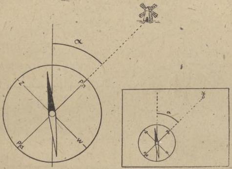
Fig. 17.
b) Another method can be used, which does not require orienting the map. Place the compass on the map so that the N–S line on the compass dial is parallel to the side edge of the map. Now read the degree mark on the dial that, when connected to the center of the compass, is parallel to the direction marked on the map (i.e., the direction connecting your position to the symbol of the feature you are heading toward). Transfer this direction to the field: turn with the compass until the N–S line aligns with the direction of the magnetic needle (accounting for declination). Then, the straight line extending from the center of the compass through the previously read degree mark will indicate the direction to the sought feature in the field.
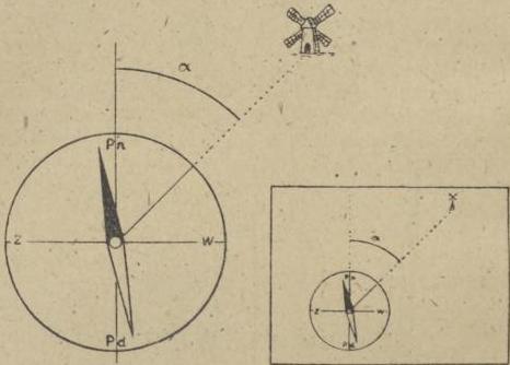
Fig. 18.
The march should last, for example, half an hour—that is, the time you estimate is needed to reach the windmill.
You yourself should follow the patrol, and after a half-hour march—or when the patrol reaches the vicinity of the windmill—stop the patrol and indicate how much it has deviated from the prescribed direction.
If the patrol must temporarily deviate from the chosen direction due to a terrain obstacle, it should, of course, after bypassing it, return to the point it had previously marked as an intermediate point in the direction of march and continue from there under the original angle.
Scouts will take great satisfaction in reaching the designated point in unknown terrain. With precise angle calculation and strict adherence to the direction, the error can be very small.
If the scouts are proficient in using the compass, you may not need to specify the point they must reach; if it is known and visible from afar, some may unconsciously veer toward it once they spot it on the horizon.
If more compasses are available, each scout can proceed independently, and it will then be clear who followed the best direction. This exercise is very beneficial.
Scan source: Polona / National Library of Poland, marked “Public Domain”. View scan — PDF pages 70–73.
Metadata
Section titled “Metadata”- Type: game
- Traits: Not stated in the source
- Source: Zygmunt Wyrobek, Harcerz w polu: zabawy i gry terenowe (1946)
- Printed pages: 64–67 / PDF 70–73
- Digital edition: Digital edition · Source record
- Open the edition at the relevant page: p. 64
- Read the source text: hwp-011