In the Forest with a Compass
Translation details
Model:mistral-medium-2604.Translated text
Section titled “Translated text”Game marked with an asterisk in the book: more suitable for older scouts.
a) In impassable terrain, such as the middle of a forest, a flag is planted. From this point, scouts set out individually or in pairs, compass in hand, in different cardinal directions, each at a different bearing (see above). They must walk for 5–15 minutes cross-country, strictly maintaining their initial direction. After this time, they turn back and return exactly in the opposite direction, i.e., to the starting point. Meanwhile, the patrol leader removes the flag and makes a mark known only to himself at the spot where it stood, then moves to another location. After the march, it is checked which scout shows the smallest deviation from the prescribed direction. It is not an error if the returning scout does not reach the mark (or misses it), as the terrain may be sloping, so the return uphill will take longer; however, a greater deviation from the marching direction is an error.
A variation and, to some extent, an extension of the exercise is to place numbered cards at easily memorable points along the route during the march, which are then collected on the return. It is also possible to go out with a compass in hand in one direction and return only by orienting oneself by the appearance of the path and collecting the cards. In the latter case, it would be advisable to send the scouts from a forest glade to which they must return, rather than from a single point as before.
b) The exercise is conducted as the previous one, but after 3–5 minutes of marching, the scout changes direction by 45° or 90° (e.g., from east to northeast or north) and continues in this new direction for another 3–5 minutes. They must return to the starting point by the same route, after which errors are assessed.
Suppose the scouts set out at bearings of 45°—110°—225°, aiming at points along the N–S line (as in Exercise No. 4b), and after 5 minutes they are to continue, changing direction by 90° to the right. In this case, at the point of direction change—note that if the compass has a degree scale on the left—each adds 90°: the first sets the needle to 135° (45+90), the second to 200° (110+90), the third to 315° (225+90). These are the azimuths for their new directions.
If the compass scale is on the right, they subtract 90°: the first, having initially set the needle to 315° (azimuth: 360–315 = 45°, see Fig. 12), sets it to 225° (315–90 = 225); the second, from 250° (azimuth: 360–250 = 110°), sets it to 160° (250–90 = 160); the third, from 135° (azimuth: 360–135 = 225°), sets it to 45°. At these new azimuths, all three continue in the direction of the N–S line as in Exercise No. 4b.
Here, not only the compass will be helpful. Scouts will use aids to facilitate orientation, i.e., they will memorize characteristic details of the path they pass, especially at the point where the path bends, such as a broken tree, a large boulder, a pit, a hut, etc. These things should be observed after passing them, as they appear differently from the opposite side. In short, both observation and orientation along the entire route.
A certain variation of the exercise is its previously mentioned form. At the point where the path bends, an orientation mark should be made to facilitate the return.
c) The difference between this exercise and the previous one is that after marching in two directions, the scout does not return by the same route but by the nearest route to the starting point. The path thus bends twice. Initially, basic and therefore easy directions are given, as in Fig. 16—then directional angles, as in Fig. 10. As in exercise b), assistants should be stationed at the points of direction change to help establish the new marching route.
The last exercise is more difficult and should only be attempted once the previous two are mastered. These exercises are harder to perform at dusk, but this should still be attempted.
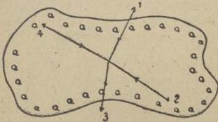
Fig. 13.
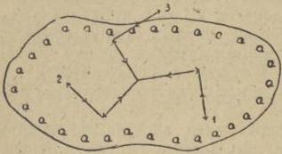
Fig. 14.
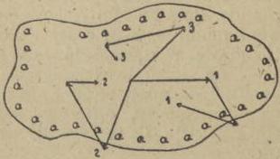
Fig. 15.
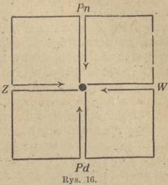
Scan source: Polona / National Library of Poland, marked “Public Domain”. View scan — PDF pages 62–65.
Metadata
Section titled “Metadata”- Type: game
- Traits: Not stated in the source
- Source: Zygmunt Wyrobek, Harcerz w polu: zabawy i gry terenowe (1946)
- Printed pages: 56–59 / PDF 62–65
- Digital edition: Digital edition · Source record
- Open the edition at the relevant page: p. 56
- Read the source text: hwp-005