Estimating Distances
Translation details
Model:mistral-medium-2604.Translated text
Section titled “Translated text”a) Measure a space of 100 m (on a road, you have it between two roadside stones) and have the entire patrol walk it in double steps, i.e., counting each time the left foot steps. After taking 66.5 such double steps, the patrol should reach the finish line. However, some will not reach it, others may pass it—the former took steps that were too small, the latter too large. Now the patrol walks back, and if necessary, repeats this a third and fourth time until every Scout, taking 133 steps, covers exactly 100 m. In this way, each will feel the muscle tension required to take a step of 75 cm, and later, when measuring any distance by steps, will strive to always feel the same degree of tension, i.e., will take normal steps of 75 cm.
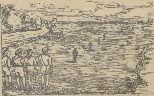
Fig. 27.
Now, have four Scouts stand in a straight line at distances of 100, 200, 300, and 400 m, one behind the other. With the rest of the patrol, stand in the extension of this line but slightly to the side. The patrol observes those standing and first tries to firmly impress upon their eyes the distance of 100 m as the basic measure for estimating greater distances.
Then draw the Scouts’ attention to the fact that an object appears smaller as it moves away, that details of the image gradually blur, and that the distances between the standing figures seem to decrease as they move farther away. These circumstances are always taken into account when estimating greater distances.
Next, position Scouts at the same distances of 100, 200, 300, and 400 m, but in different directions and against the same background. During positioning, the patrol should face away from those being placed. Based on the previously seen image, each Scout then estimates the distance of all those positioned.
Afterward, the actual distances are given, and the entire patrol observes them to better imprint these distances in their minds.
This concludes the first exercise. Each exercise should always be repeated with the previously positioned Scouts.
b) Two patrols stand opposite each other at a distance of 500 m. This space is marked by two sticks. Each patrol has a signaling flag. The white patrol turns away, and the red patrol sends one Scout to a distance of 300 m, so he stands at a distance of 500–300 m, i.e., 200 m from the whites. Flag up: The whites turn around, and each estimates the distance of the red Scout, writing it on a piece of paper (corrections are not allowed). After 50 seconds, the red Scout returns, his comrades turn away, and the whites send one of their own to a certain distance, e.g., 100 m (500–100 = 400 m from the reds). On the flag signal, the reds now estimate his distance, and so on. After an agreed number of estimates, the patrol leader collects the notes, compares them with the actual distances (held by the opposing patrol), and then both patrol leaders determine which patrol made fewer errors in estimation. That patrol wins.
c) Position Scouts at the same distances in different directions. One stands against a light background, another against a dark one; one on a uniform plain, another in undulating terrain, partially obscured; one lies down, another kneels or stands (always both at the same distance). Instruct the rest to estimate the distance of each pair, and when errors are made, point out the apparent difference in distances and thus the underestimation or overestimation of the same distance, depending on the conditions in which the observed object is found. Also note that distances are estimated differently on a bright or cloudy day, a dry or humid day, when the sun is behind or in the face, etc. (see the relevant handbook). Then have the estimators lie on the ground and note that the same object appears more distant from this position.
d) In the fourth exercise, independent estimation is already practiced within 100–400 steps, taking into account various estimation conditions. Each Scout individually and independently records in a corresponding card (below) the estimated distance of all objects in sequence from left to right. The patrol leader then provides the actual distances and enters them into each Scout’s card, also calculating the percentage of error (see below). In this way, each Scout becomes aware of the type of error made in estimation.
Next, those who were previously positioned take their turn at estimating.
As for competitions between whites and reds, both patrols gather together, and each estimates individually and independently. After calculating the percentage of errors in the cards, it is easy to see which patrol estimated better.
e) Next, proceed to estimating distances not as before in depth, but across the terrain, i.e., not the distance of an object from oneself, but the space between two objects in the terrain. For this purpose, position Scouts in a straight line as in exercise a), but stand with the rest not in its extension but to the side. Note that, as before, the distances between those standing appear smaller the farther one stands from them.
Then position Scouts at various distances from each other (within 100–400 m) and estimate them from different points.
f) Only when Scouts can accurately estimate distances up to 400 m under various conditions with a relatively small error should you proceed to estimating up to 800 m, and gradually even greater distances. The procedure is as in a) and d).
Such larger spaces are divided by eye into halves or even quarters, and then the half or quarter is estimated. This greatly facilitates estimation and guards against excessive error.
One should always strive to gain practice in estimating from a prone position. The standing position is only an introductory posture in learning.
Relatively quickly, one gains skill in estimation, but it is also quickly lost with prolonged neglect. These exercises should therefore be practiced frequently, and every march on an excursion provides an opportunity: a few or a dozen Scouts sent ahead mark the starting point for estimation and, positioning themselves at various distances, wait for the approaching patrol. After estimation, the marching patrol joins them to send others ahead for a similar exercise at another location. This approach saves a lot of time and adds variety to the march.
In such an exercise, each Scout sent ahead must be given the distance at which to stand, the position to take (standing, kneeling, lying), and the signal (whistle or flag) on which to change position, and on which to change distance and to what. If these things are not established, much time will be lost, and the exercise will fail. After the exercise, the actual distances should be provided to the Scouts.
Similarly, after estimating people, various terrain objects are also estimated, e.g., the distance to a church, house, cart, etc.
Distance Estimation Card Template
Section titled “Distance Estimation Card Template”Patrol | Surname
| No. | Type of Object | Estimator’s Position | Estimate | Actual Distance | % Error | Notes |
|---|---|---|---|---|---|---|
| 1 | Kneeling Scout, etc. | standing | 400 m | 500 m | 20 % | Object difficult to distinguish |
| 2 | ||||||
| 3 | ||||||
| 4 | ||||||
| 5 | ||||||
| 6 | ||||||
| 7 | ||||||
| 8 | ||||||
| 9 | ||||||
| 10 |
Table for Calculating % Error
| For an actual distance | an estimation error of approximately (in meters) | ||||||||||||||
|---|---|---|---|---|---|---|---|---|---|---|---|---|---|---|---|
| 5 | 10 | 20 | 25 | 50 | 75 | 100 | 150 | 200 | 250 | 300 | 350 | 400 | 450 | 500 | |
| represents an approximate % error of | |||||||||||||||
| 50 m | 10 | 20 | 40 | 50 | 100 | — | — | — | — | — | — | — | — | — | — |
| 100 | 5 | 10 | 20 | 25 | 50 | 75 | 100 | — | — | — | — | — | — | — | — |
| 150 | — | 7 | 13 | 17 | 33 | 50 | 67 | 100 | — | — | — | — | — | — | — |
| 200 | — | 5 | 10 | 13 | 25 | 38 | 50 | 75 | 100 | — | — | — | — | — | — |
| 250 | — | 4 | 8 | 10 | 20 | 30 | 40 | 60 | 80 | 100 | — | — | — | — | — |
| 300 | — | — | — | 8 | 17 | 25 | 33 | 50 | 67 | 83 | 100 | — | — | — | — |
| 350 | — | — | — | 7 | 14 | 21 | 29 | 43 | 57 | 71 | 86 | 100 | — | — | — |
| 400 | — | — | — | 6 | 13 | 19 | 25 | 38 | 50 | 63 | 75 | 88 | 100 | — | — |
| 450 | — | — | — | 6 | 11 | 17 | 22 | 33 | 44 | 56 | 67 | 78 | 89 | 100 | — |
| 500 | — | — | — | 5 | 10 | 15 | 20 | 30 | 40 | 50 | 60 | 70 | 80 | 90 | 100 |
| 550 | — | — | — | — | 9 | 14 | 18 | 27 | 36 | 45 | 55 | 64 | 73 | 82 | 90 |
| 600 | — | — | — | — | 8 | 12 | 17 | 25 | 35 | 42 | 50 | 58 | 67 | 75 | 83 |
| 650 | — | — | — | — | 8 | 12 | 15 | 23 | 31 | 38 | 46 | 54 | 62 | 69 | 77 |
| 700 | — | — | — | — | 8 | 11 | 14 | 21 | 29 | 36 | 43 | 50 | 57 | 64 | 71 |
| 750 | — | — | — | — | 7 | 10 | 13 | 20 | 27 | 33 | 40 | 47 | 53 | 60 | 67 |
| 800 | — | — | — | — | 6 | 9 | 13 | 19 | 25 | 31 | 38 | 44 | 50 | 56 | 63 |
| 850 | — | — | — | — | 6 | 9 | 12 | 18 | 24 | 29 | 35 | 41 | 47 | 53 | 59 |
| 900 | — | — | — | — | 6 | 8 | 11 | 17 | 22 | 28 | 33 | 39 | 44 | 50 | 56 |
| 950 | — | — | — | — | 5 | 8 | 11 | 16 | 21 | 26 | 32 | 37 | 42 | 47 | 53 |
| 1000 | — | — | — | — | 5 | 8 | 10 | 15 | 20 | 25 | 30 | 35 | 40 | 45 | 50 |
Example:
The actual distance is 750 m.
A Scout estimated it as 1,000 m, so the error is +250 m.
In the table, in the horizontal row next to 750 and in the vertical column under the error value 250, we find the number 33—thus the % error is +33%.
Source of scan: Polona / National Library of Poland, marked “Public Domain”. View scan — PDF pages 105–111.
Metadata
Section titled “Metadata”- Type: game
- Traits: Not stated in the source
- Source: Zygmunt Wyrobek, Harcerz w polu: zabawy i gry terenowe (1946)
- Printed pages: 99–105 / PDF 105–111
- Digital edition: Digital edition · Source record
- Open the edition at the relevant page: p. 99
- Read the source text: hwp-039