With a Rough Sketch in Hand
Translation details
Model:mistral-medium-2604.Translated text
Section titled “Translated text”Game marked with an asterisk in the book: more suitable for older scouts.
Scouts receive a sketch of a certain area, on which only a few of the most important landmarks are drawn and the north direction is marked. Each has a point in their sketch marked with a cross, which they must locate using a compass and stop at. The patrol leader checks, using a map, whether each scout is in the correct place.
At the start of the march, everyone is only told that the sought-after section of terrain is, for example, in the Z direction, and if one wishes to make the task easier, the distance (e.g., 3–5 km) or the time it will take to reach it is also provided.
The exercise can be varied by adding the task of supplementing the sketch by drawing in a few more prominent terrain features, whose positions must be determined using the compass so that the sketch now represents a complete and valuable depiction. Scouts must first locate the terrain shown in the sketch and then continuously orient themselves to the cardinal directions in order to place new details in the correct spots on the sketch.
As with the previous exercise, an enemy patrol can also be added here.
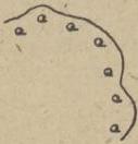
Fig. 19.
Scan source: Polona / National Library of Poland, marked “Public domain”. View scan — PDF page 77.
Metadata
Section titled “Metadata”- Type: game
- Traits: Not stated in the source
- Source: Zygmunt Wyrobek, Harcerz w polu: zabawy i gry terenowe (1946)
- Printed pages: 71 / PDF 77
- Digital edition: Digital edition · Source record
- Open the edition at the relevant page: p. 71
- Read the source text: hwp-016