Cross-Country with a Compass
Translation details
Model:mistral-medium-2604.Translated text
Section titled “Translated text”After explaining the construction and use of the compass (busola) in the field, the patrol sets off with a compass in hand, heading north, south, east, or west. (For repeated exercises, intermediate directions are chosen). The requirement is only to maintain the general prescribed direction, and it is the patrol leader’s duty to choose the most suitable route for the patrol. He also checks the march using the compass.
a) Suppose I need to go in the direction N—E. I place the compass on my palm and turn, holding it at chest height, until the black end of the needle (the north pole) aligns with N. Then, I place a matchstick on the glass so that, passing through the axis of the needle (i.e., the center of the compass), it covers the line marking the N—E direction. Now, I aim at the terrain, looking for a distant object (a tree, a hut, etc.) lying exactly in the extension of the matchstick, and head toward it (Fig. 10). Upon reaching it, I repeat the process, finding a second point on my line of march in the same way, and so on.
If, during the march, the target disappears from sight due to the terrain’s configuration, this will not affect the direction of the march as long as I keep the compass set, i.e., constantly ensuring I do not deviate from the direction, and continue moving in the direction of the matchstick, i.e., the N—E line.
If I encounter an obstacle (e.g., a swamp), I memorize a visible point on the terrain that lies on the line of march beyond the obstacle, and after bypassing it, I return to that point and continue cross-country.
(The angle contained between the magnetic needle and the direction to any point on the terrain, read to the right of the magnetic meridian (in this case, the angle between N and N—E = 45°), is called the directional angle or azimuth.
We orient ourselves according to the azimuth during a march through a large forest and generally when it is difficult to navigate using a map).
To verify whether the scouts are indeed moving in the assigned direction and to spark greater interest, a scout can be placed in hiding at a terrain feature lying exactly on the line of the assigned direction. It will later be seen who deviated the least and who the most from the correct direction. In this case, the scouts set off separately, at intervals.
b) Instead of placing a matchstick on the compass, I can aim at the point I need to reach using the N—S line drawn on the bottom of the compass. Since there is a degree scale (from 1°—360°) on it, it is sufficient to subtract the angle indicated by the north pole of the needle from 360°. The resulting azimuth of the given point
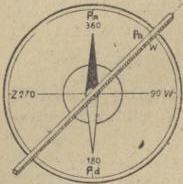
Fig. 10.
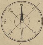
Fig. 11.
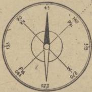
Fig. 12.
(in Fig. 11, the needle indicates 315°, so the azimuth is 360°—315° = 45°, as above under a).
If the degree scale is placed in the opposite direction, i.e., to the left rather than the right of N (Fig. 12), I can read the directional angle directly from the compass after aiming the N—S line at the point in the terrain (in this case, 45°). It is sufficient to aim as under a), but instead of the matchstick, use the N—S line, ensuring the needle aligns with 45° (in the first case, 315°), since I was to go in the N—E direction¹).
Source of scan: Polona / National Library of Poland, marked “Public Domain”. View scan — PDF pages 59–62.
Metadata
Section titled “Metadata”- Type: game
- Traits: Not stated in the source
- Source: Zygmunt Wyrobek, Harcerz w polu: zabawy i gry terenowe (1946)
- Printed pages: 53–56 / PDF 59–62
- Digital edition: Digital edition · Source record
- Open the edition at the relevant page: p. 53
- Read the source text: hwp-004